Friday, March 13, 2020

Kfar Hasidim to Nazareth on Israel National Trail: Day 40

Rain, rivers and mud made today a tough challenge.
Periodic gusts of wind shaking my tent meant my sleep was somewhat disturbed. By morning the wind had died down but rain drops were giving the flysheet a real thumping when I woke (although the tent stayed surprisingly dry). After turning over for another 20 minutes, the rain had stopped and I quickly decamped.

Cow pasture in a wooded valley beside the trail.

As I had completed a good distance yesterday, there was a possibility that I could reach Nazareth tonight. Initially this seemed achievable as I covered the first 10 kilometres of cow pasture, bushes and trees at a good pace, reaching Hanezirim Mill. Unfortunately, directly after the old mill I needed to cross a river. There is probably no water in it at all in summer, but last night's rain had turned this little brook into a raging torrent. I removed my boots and socks, and put on my canvas shoes normally used in hotels, made sure everything was in "dry bags" in case I fell over, and stepped slowly into the muddy water. The water came up to the bottom of my shorts as I very carefully made my way across. The river bed was very uneven so care was essential. On occasions such as this trekking poles would be useful to maintain balance (not brought due to weight considerations).

River in flood which I had to cross

Safely reaching the other side I dried my feet with my handkerchief, replaced my boots and socks and continued along the trail, or at least tried to. The river had washed away part of the trail so that there was nothing to walk on between the foaming water and a fence. Consequently I climbed up to a path higher up the side of the valley, sliding on mud and using my hands for support (and generally plastering mud all over me and my rucksack). I continued to the town of Ka'abia. As I approached it, letting a herd of cows pass me (the second of the day), the rain began falling heavily. By the time I was in the town it was torrential, with rivers of water running down the street. I sheltered in someone's car port for a while, then headed down the street hoping for a cafe. A car stopped to offer a lift, but I declined (nobly committed to finishing the trail on foot). As flashes of lightening were quickly followed by the rumble of thunder, and there was no sign of a place for coffee I sheltered again under a shop front. At last the rain eased off, and after making sure all my essential stuff was being kept dry I climbed up a valley out of town and followed the trail over a ridge.
In the next valley I again reached what would normally be a stream but was now swollen into a fast flowing river of uncertain depth. At the point where the trail crossed the force of the water looked too great to contemplate a crossing. Instead I went downstream to where a vehicle track crossed. Then changing into my canvas shoes again I made my second river crossing of the day. Regaining the trail, it climbed through pine woods before making a complicated crossing of a highway interchange. More trees followed until I reached Rabbi Yehuda's tomb in a period when it had stopped raining for a little while (he was an important Rabbi who edited the Mishnah). A man and his son were sitting outside and called me over to join them in a cup of tea. Sweet and green the water was boiled on a small camping stove. It was very welcome after a difficult day, an act of kindness I much appreciated and revived my spirits. Inside the tomb, where it was suggested that repeating a psalm would be appropriate, a man was praying. Stopping briefly, he asked for some money, which I gave him feeling one act of kindness deserves another.
A little time later I climbed into the town of Mashad. I could hear a lot of cars sounding their horns, a wedding I thought, but no, parked cars meant reduced a road to a single lane. Cars were trying to come from both directions creating deadlock. Instead of reversing they were all sounding their horns. A few "one way" streets would help.
Reaching the junction with a major highway just outside Mashad in the rain, I used the bus shelter to avoid wetting my phone and asked Google which bus to catch and when. The number 24 arrived 15 minutes later as it said it would. I managed to use the bus card I had acquired in Jerusalem and was dropped off by the old city of Nazareth some time later. I checked into the Abraham hostel (also called the Fauzi Azar Inn) choosing to have a room of my own, which has a vaulted stone ceiling. It is a 200 years old Ottoman building with a courtyard and lots of character. The call to pray reminds me that I am in an Arab area, the sound of multiple muezzins (all fairly tuneful) giving a Middle Eastern atmosphere that is missing in much of Israel. I have spotted a number of mosques today. Tomorrow I hope to visit churches.

My room in Fauzi Azur hostel, note my sleeping bag drying out over a chair, a useful place to wash the mud off my belongings

Thursday, March 12, 2020

Nahal Me'arot to Kfar Hasidim on Israel National Trail: Day 39

Rock strewn paths made the going slow today as I went up and down mountains among bushes and trees.
Yesterday at dusk and this morning I was under sustained attack by mosquitoes after my blood. This made me pack up very quickly while simultaneously swatting at mosquitoes. A big spodge of (my) blood meant I had killed one after she had done her worst. I was generally put in a poor mood, not helped by the complicated path going over rocks up and down the side of the hill, difficult to follow with all the twists and turns despite frequent waymarks. I was glad the next bit of track was on a vehicle track beside a banana plantation. The bunches of bananas were covered in plastic and the whole plantation was under fine netting, patched up in places where presumably some animal had tried to get in.
Reaching Ein Hod my mood changed from black to golden for two reasons. Firstly the village was populated with a wide range of sculptures, many causing me to stop and admire, intrigued at what the artist had produced and was maybe trying to say. Secondly there was a shop selling cups of coffee (and a banana and chocolate).

Large bronze in Ein Hod

Thus fortified I followed little paths up and down hills covered with bushes and shrubs, over large rocks, beside, between and below limestone outcrops. I passed two parties of school children dressed in blue, being lectured about something. Outdoor hikes seem more part of the school curriculum in Israel than in Britain. 
To reach the town of Isfiya the trail took me up a stream bed over dry waterfalls. There were some rungs and rails cemented into the rock to help you up, needed as the rock was slimy and slippery. It reminded me of the desert section of the trip except here I was surrounded by trees.

Rocky section of trail.

Metal rungs to help on slippery rock

I reached Isfiya at 1:30 pm, too early to stop, so after a hot dog and coke I continued downhill towards the village of Yagur. Although it was a short distance away the path was like a concertina, zigzaging down the hill among the trees, consequently it took me rather longer than expected, not helped by intermittent rain. Once down at Yagur it was fast progress across the valley to Kfar Hasidim. I then continued a little way beyond this village, climbing up through dense bushes until I found a suitably flat piece of cow pasture near the top of a hill to pitch my tent. Only problem, other than avoiding cowpats, is the strong, gusting wind. I pitched my tent pointing into it, but the wind has now changed direction and is hitting me broadside, flexing the tent's single pole back and fore, sometimes violently. Hope the DAC aluminium sections of the pole do not snap...

Wednesday, March 11, 2020

Zakhron Ya'akov to Nahal Me'arot on Israel National Trail: Day 38

A walk through the woods today with no great highlights.
With plans to wild camp for a few nights I visited the supermarket in the centre of town to stock up on tuna, tortillas, peanut butter, oranges and cereal bars. Suitably prepared I returned to the trail which made a lengthy circumnavigation of Zikhron Ya'akov. This included wading through a river (Nahal Daliya) beside a highway. Too deep for my boots I removed them and my socks and crossed in my canvas "hotel" shoes, now rather wet.
Most of today was through woodland, sometimes taller pine trees but usually smaller trees and bushes of various types, densely packed. In the early part of the day the view of quarries and tips was not pretty, it improved later although the vistas down the coastal plain were dominated by trees, fruits and bananas being cultivated under fine, white netting (presumably to keep the birds and insects out) and poly tunnels. The trail repeatedly went up and down the edge of the Mount Carmel range. As there were many crossing tracks and paths, it was easy to miss a waymark indicating a turn. I retraced my steps on one occasion to follow the correct route (a frustrating experience), but next time I simply took a slightly different route. In places I was following forest tracks, with pools of water and deep mud at times, at others the route took pretty paths, although jagged rocks meant progress could be slow. The trail including hiking up a stream bed, fortunately with no water but the low vegetation kept grabbing my rucksack. 

Muddy track with some typical vegetation each side.

The one site mentioned in my guidebook concerned an area inhabited by Arabs before they were displaced by the 1948 war. One intact building remained which looked like a small mosque as there was a mihrab, a small alcove showing the direction of Mecca.

A section of path

A rocky section of path

As evening approached there was a fine display of miniature blue iris. Although the red anemones are now past their best I saw many other attractive flowers.
The geology was mainly limestone, resulting in a number of caves and holes in the ground. I am camped at the entrance to the Me'arot caves where evidence of many years of human occupation was found. Unfortunately, by the time I arrived, after a slow day, the visitor centre and caves were closed.

Tuesday, March 10, 2020

Hadera to Zikhron Ya'akov on Israel National Trail: Day 37

Main event of the day was visiting the extensive, ancient remains at Ceasarea.
Today's walk began by walking over undeveloped land to a Power station. First commissioned in 1981 its workings are not enclosed in walls, instead the girders holding the plant up are visible on the outside. A very different architectural style to the 1930's Power Station north of Tel Aviv (see day 35). A long jetty into the sea allows for unloading the coal required to fuel the boilers. Such coal burning power stations are now considered outdated and detrimental to the environment. With gas discoveries offshore Israel in recent years modern combined cycle power plants using gas are likely to replace the use of imported coal. Indeed it looked like there was a large offshore, gas production in the sea, vaguely visible through the haze from where I walked today. Just before the power station was a park area beside a river, several men with fishing rods were hoping for a catch. The white suspension bridge crossing the river seemed designed with a view to aesthetics as much as function.
After a section of road I reached the Sdot Yam Kibbutz. The trail seemed to be blocked off by a new fence enclosing some house construction. I tried to work my way around the fence but found no clear route, so instead I just walked straight through the village. There were barriers for vehicles, but not for pedestrians. I was checking this evening and there is a recent update to the route on the Tapatalk site, it was issued after I had started my walk. I should have headed east before reaching the kibbutz fence.
The entrance to the remains of ancient Caesarea was directly after Sdot Yam. Conceived and built by King Herod the ruins included an amphitheatre, a chariot racing track, villa and bathhouse. Later a Crusader castle occupied the site. There were a two short films describing the history. Tour groups of numerous nationalities were visiting the large site with me. A South African lady sang their National Anthem in the theatre, demonstrating its acoustics. 
Leaving the main archaeological campus I walked along the beach beside the aqueduct that once supplied the ancient city with water. The beach continued after I lost sight of the aqueduct, a period of slow progress for me as my boots sank into the sand. After passing a little harbour surrounded by fisherman's shacks I walked over some mosaic remains in the dunes and beyond the headland there were some surviving sections of a bridge built in 1898.

Aqueduct at Caesarea

I followed the trail inland to the Arab town of Jisr A-Zarka, where I enjoyed a humus and pita bread lunch, served with tomatoes, onions, olives, finely chopped green chilli and a expresso coffee to finish off.
The next section proved difficult as parts of the trail were flooded, overgrown or blocked by a herd of cows. I worked my way around the obstacles often beside more lengths of Roman aqueduct. The trail runs under a major railway line at a bridge intended for a river. At the same time it also crosses the river. On this occasion the river, swollen with recent rain, was filling the entire space beneath the bridge with fast moving grey water. I decided against removing my trousers and wading through but instead made a three kilometre detour to arrive on the other side of the bridge and river. On the way was an abandoned quarry, the trucks still standing on a rusted railway, waiting to be filled from the  silent, overhead gantries.

Limestone pavement on the cliff edge overlooking the coastal plain

The path climbed a hill to a limestone pavement extending to the edge of a cliff. On top of the hill there were more archaeological remains, mainly of a Byzantine villa, but with older and more recent structures at the same site. In addition there was a pretty good view down the coast.
A little later I reached the Ramat Hanadiv gardens where Baron Edmond de Rothschild and his wife are buried. He was instrumental in helping finance the early Jewish settlers in Israel. The memorial gardens were closed by the time I arrived, and I needed to move smartly to reach my hotel before dark. But on the way I was waylaid by more archaeological remains including a short, small Roman aqueduct that supplied a bathhouse from a spring in a tunnel. Water was still flowing along the aqueduct which was built some 2000 years ago. A little further down the hill there was a grey military looking boat, over 10 metres long, stranded miles away from any water, sitting by the roadside.
Finally reaching the hotel, myself and my passport was carefully scrutinised, page by page, by the serious looking receptionist, I assume to confirm I had not recently been to any countries affected by the recent Coronavirus outbreak. 

Monday, March 9, 2020

Natanya Poleg to Hadera on Israel National Trail: Day 36

Iris, turtles, and a man painting Israel National Trail waymarks were some of the highlights today.
According to my trusty Red Guide the first sight today after leaving Natanya Poleg should be the iris reserve. After a large earth carpark I walked into the reserve. Some men asking after my progress on the Shvil Israel (the Israel National Trail) told me there were hundreds of Iris to be seen, but I was having trouble seeing any. I headed off left towards the centre of the reserve but although there were many other lovely flowers, no iris. Then I spotted one under a white broom (i.e. a broom bush with small white flowers). Having spotted one I was soon seeing them everywhere. They were a dark, deep purple quite different from the usual blue and yellow ones. Some had attracted small snails.

Wild iris

Much of today was along the beach, either on the sand or on concrete paths above it. Through the large town of Netanya, the paths above the beach were in a manicured setting, among carefully tended grass and palm trees. On the beach, the width of sand in places was so thin that I was paddling through water as the small waves washed in. The soft cliffs were unstable, and there were landslips in places, large blocks of rock were sometimes used to protect the base of the cliff from further erosion. 

Promenade by Netanya.

I made a diversion up the cliffs to Independence square in the centre of Netanya for a coffee. French was very much in evidence for some reason and it had a proper French croissant with my coffee (i.e. no sugary stuff on top).
Later on two students sun bathing on the beach asked after my progress on the Shvil Israel and gave me a glass of tea they had just brewed on a small camping stove (very refreshing as the day was hot). I am often asked when I started and why I decided to walk this trail. They were on the beach as it was Purim today, a celebration of Esther saving the Jews, so it was a holiday. The celebration started a few days ago. It can involve dressing up, and I have seen a few frilly frocks in bright colours on men as well as women. 
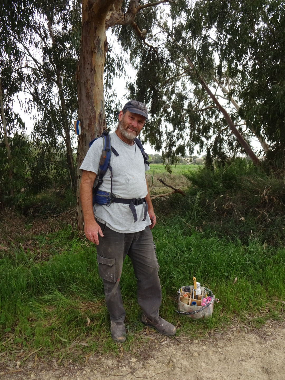
On reaching a river the trail turns inland following it upstream for a few kilometres. I passed the ruin of an Ottoman customs post and then noticed a man painting an Israel National Trail waymark. He was adding an orange dot to indicate that this was also on the Sharon trail which went inland from this point. I thanked him for his work which makes it a lot easier to find the way. 

The man who paints the waymarks on the Israel National Trail.

At the point where the trail leaves the river, there was a picnic site on the other bank with an ice cream van requiring a visit from myself (also an observation tower). While enjoying my ice cream I was looking at the large catfish in the muddy river, for some reason many had collected at this spot and were circling around. Then a small turtle surfaced, and as I looked closer I saw a much larger one, a metre and a half or so long, which slowly rose to the surface then dived deeper as it swam along. 

Turtle in river.

After crossing some fields, avoiding a flooded section of track, and then walking through a half built industrial estate and some rough ground I reached Hadera woods. I had considered camping here but decided against as it was not so far from built up areas. However, the mature Eucalyptus trees, without too much undergrowth, would have made a good place to pitch a tent. Having already booked a room at the Ramada beachfront hotel, I headed there. I was upgraded to a suite on the 19th floor, from which I watched the round, red sun set below the distant haze covering the sea.
Dinner was at Benny the fisherman, by the beach. I ate too much, I should not have ordered the chocolate souffle for dessert or ate the chocolates left by the hotel in my room.

Sunday, March 8, 2020

Tel Aviv to Natanya Poleg on Israel National Trail: Day 35

A very different day from all previous days: a walk along the coast on the beach, the promenade, through dunes and by an Art installation.

1930's Power Station by Tel Aviv

After yesterday's trudge through mud, starting today by walking along the promenade with the morning joggers was a really pleasant change. A stylish 1930's lighthouse and I thought an equally stylish 1930's power station in white, were the first sights I walked by. There was then a long section with the beach on one side, and an empty area behind barbed wire fencing on the other. Maybe an old airport as there was a lonely control tower. It did mean you had to run over a kilometre if there was a Tsunami warning as the fencing prevented you heading directly inland. Tsunami signs pointed which direction to run in. I had not considered such an event in the Mediterranean before, they usually seem to devastate the Far East, however there are earthquakes in the Mediterranean area so a Tsunami is not so unlikely. 
Looking for where the trail went after the concrete promenade ended I met a German guy also walking the Israel National Trail having started at a similar time to me. We walked together along the beach a little way, sharing experiences. I stopped for a coffee at a Marina. Service was sluggish but it wasn't so bad watching yachts come and go in the sun. Later I joined a 78 year old Israeli who was walking some 20 kilometres for a bit of exercise. He was certainly fit as he sped up the hill to the Sidna Ali mosque (where the call to midday pray was being sung). He came to Israel some 44 years ago, and seemed very glad to have left the Soviet Union. There was a crazy house built into the cliff he showed me. Lots of curves in concrete and mosaics, a bit in the style of Gaudi but not as colourful. 
I left him when I visited the Apollonia archaeological park. There were remains of a Roman villa and some cisterns but the main sights were the remnants of a Crusader castle and town which overlooked the sea. It was destroyed by the Muslim Mamluks after a siege in 1265.

Sea shore before Netanya

I had imagined that it would be very urban along the coast, but beyond the fortress there was a long section of undeveloped open land and well vegetated sand dunes. Cliffs were steep and crumbling so I avoided going too close. Shrubs in bloom lined part of the track and flowers of many colours were spread among the grass. There was an art installation in one place with several large pieces made of wood and wooden cable reels.

Artwork made of cable reels.

City of Netanya beyond the sand dunes.

As the sun began to approach the sea I met my German colleague again. He was planning to camp among the trees whereas I had booked a room in "Q" hotel, which is where I am now. I have showered, washed some clothes and eaten at the hotel buffet. The beach is nearby, it seems an area used by kite surfers, there were several out on the sea as I turned inland to my hotel.

Kite surfers in the evening light at Natanya Poleg.

Saturday, March 7, 2020

Petah Tikva to Tel Aviv on Israel National Trail: Day 34

Rain yesterday evening had made the trail muddy. I slowly, slithered around the interminable meanders of the River Yarkon before reaching a glorious park with tarmac paths.
First I had to return to the trail some 6 kilometres from my hotel. Initially along easy roads, quiet as it was Saturday, people were walking their children in the pleasant areas between the tower blocks. Then the going became difficult as I crossed fields and rejoined the Israel National Trail. An inch of so of mud stuck to the bottom of my boots.

Petah Tikva, tower blocks but some nice areas between them

Sweet singing sounded from a hall at the Baptist village, a centre for the denomination in Israel. After that the trail ran along side the River Yarkon until the end of the day. The river was extremely convoluted, the meanders massively multiplying the distance I had to walk such that following an hour or so of walking I was astonished at the small distance I had moved on the map. There were many places were the mud was deep, coating my boots and trouser bottoms with mud as I tried to find the firmest path through. Slips and slides threatened to end in a full fall, which I narrowly avoided.
Two of the under passes below busy highways were particularly difficult with thick, soft and squishy mud combined with large pools of opaque water of indeterminate depth. I met a large group coming from one. Their leader advised me to risk a crossing of the busy four lane highway, but two of the ladies said quietly that they had managed the underpass. I also managed it by walking on the steeply sloping, but rough concrete that formed one edge of the underpass. The group included a lady from the Geography department of Haifa University who was interested in why people walked the Israel National Trail, today I wondered myself.

Muddy track beside the Yarkon River

In truth, without the mud it would have been a pleasant walk. The river was edged by reeds and bamboo, the latter forming a arch over the trail in places. Eucalyptus trees bordered the river, which was surrounded by fields or citrus orchards. Curiously the oranges were not being picked but left to fall and rot on the ground. I disturbed a heron and spotted a pair of parrots and a small turtle swimming in the river. Some unknown creatures jumped into the water as I approached. 
On reaching an area of parkland my spirits rose, my endurance test in the mud was over as I wandered along tarmac paths. Being the weekend lots of people were out, sitting on the grass, jogging, cycling or travelling on electric scooters, often two people on the same scooter. There were families, dogs on leads, couples canoodling, Dads barbecuing beefburgers, filling the air with smoky, barbecue smells. The park followed the river, often on both sides. There was a boating lake, an outdoor "gym", an impressive arrangement of climbing walls, and a place selling pancake like things, I asked for one with nutella.

Park beside the Yarkon River in the outskirts of Tel Aviv

People were backlit by the sun, low in the sky as I walked towards my accommodation for the night, the Spot Hostel, where I have a small double room. It is indeed small but it has everything required, bed and bathroom. I found something to eat in the nearby port area, no longer a port but a place with restaurants, food stalls (many closing when I arrived) and shops.
Looking forward to an easier day tomorrow.